ИНФРАКРАСНЫЙ И ГИПЕРСПЕКТРАЛЬНЫЙ МОНИТОРИНГ ПОЖАРОВ
(Российско-Германское предложение по международному проекту наблюдения Земли из космоса)
|
|||||||||||||||||||||||||||||||||||||||||||||||||||||||||||||||||||||||||||||||||||||||||||||||||||||||||||||||||||||||||||||||||||||||||||||||||||||||||||||||||||||||||||||||||||||||||||||||||||||||||||||||||||||||||||||||||||||||||||||||

|
Development time |
2 -3 years |
|
Lifetime |
4 years in orbit |
|
Launch constraints |
low-cost launch into LEO
(as auxiliary payload) |
|
Mission type |
micro-satellite constellation mission with
operational objectives |
|
Cooperation |
German and Russian institutes and companies |
|
Ground base segment |
Russian and DLR ground stations |
|
Funding |
DLR-German space agency and Russian Academy of
Sciences, Rosaviacosmos, industrial enterprises, investors |
The optimal
infrared channel selection for forest fore monitoring is based on the
comparison of forest fire flaming spectra and
standard spectra of natural vegetation.
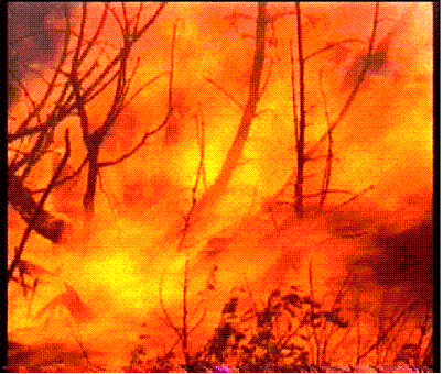
Signatures of Vegetation Fire and Background
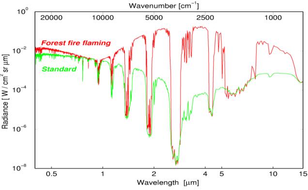

This comparison leads to the
following conclusions:
·
spectra contain
information on land surface, atmospheric gases and aerosols;
·
the second atmospheric
window (MIR) is the optimum for the „hot spot“ detection.
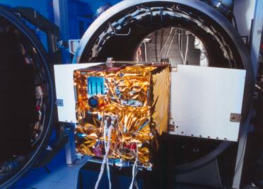
The key elements
of FMC Instruments
The
2-channel-infra-red
sensor
system (15kg, 90W) A VIS/NIR
2x 512pixel CdHgTe
detectors
pushbroom
GSD:
185m Sensor
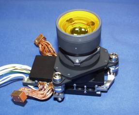
Hyperspectral Sensor instrument (20kg, 30W)
Key elements
Acusto Optical Micro Channel Plate –Detector
tunable Filter Sensor
The
FMC Instruments
Payload
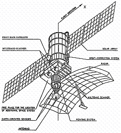
platform of BIRD-type with assembling tools
|
|
VIS/NIR |
MWIR |
TIR |
Hyperspectrometer |
|
Wavelength |
600-670nm |
3.4-4.2µm |
8.5-9.3µm |
0.4-0.8µm |
|
Focal length |
21.65mm |
46.39mm |
46.39 mm |
~700mm |
|
Detector |
CCD |
CdHgTe |
CdHgTe |
MCP |
|
Ground pixel
size |
185m |
370m |
370m |
20m |
|
Ground
sampling distance |
185m |
185m |
185m |
20m |
|
Swath width |
533km |
190km |
190km |
20x20km2 |
at
572km orbit
altitude
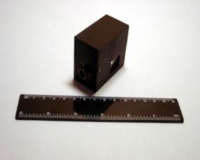
Payload platform of BIRD with assembling tools
(without the hyperspectrometer)
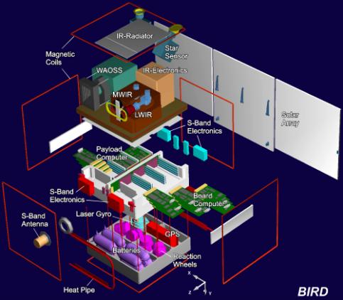
FMC
Payload Mass and Power Budget
|
system |
mass |
Power budget |
|
IR-System |
15kg |
90W |
|
VIS/NIR-Sensor |
4kg |
10W |
|
Hyperspectrometer |
20kg |
30W |
|
Star sensors,
Magnetometer |
3kg |
5W |
|
Structure |
2kg |
|
|
Harness |
1kg |
|
|
Total: |
45kg |
135W |

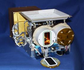
BIRD payload
– top view
Comparison
FUEGO and FIRE MONITORING CONSTELLATION
|
Parameters |
FFEW-FUEGO |
BIRD-FMC |
|
Orbit geometry |
700 km/47.5 ° |
700 km |
|
No. of satellites |
12 |
3 or 4 |
|
MIR channel (res., swath) |
144/72 m, 250
km |
550 km |
|
TIR channel (res., swath) |
390 m, 250 km |
550 km |
|
VNIR
channel (res., swath) RGB-CCD
channel (res., swath |
100/25 m ,
250 km - |
- 225 m , >
500km |
|
Minimal
resolvable 800 K fire area
at nadir |
~5/20 m2 |
~5/20 m2 |
|
Revisit Time |
30.4 minutes |
12 Hours |
|
Average fire detection |
15.2 minutes |
6 Hours |
|
Data transmission |
L-Band,
direct to users |
S-Band,
direct to users |
Comparison
between hyperspectrometer parameters
|
|
Wavelength
Range |
Best
spectral resolution |
Measurement
of Polarization |
Ground
pixel size |
Size of a
data take |
|
Warfinghter-1 (OrbView3-4) |
0.45-2.5µm |
11.4nm |
No |
8m |
5x20km2 |
|
Hyperion |
0.4-2.5µm |
10nm |
No |
30m |
7.5x100km2 |
|
FTHSI |
0.47-1.05µm |
1.7nm |
No |
25-250m, |
6-26km x |
|
“Astrogon-
Vulkan” |
0.25-2.5µm
|
1nm |
Yes |
5m |
3x3 km2 |
|
“Astrogon
Light” Hyper-spectrometer |
0.4-0.8µm |
1nm |
Yes |
10m |
10x10km2 |
The requirements to the BIRD bus – type
satellite bus:
hsuitable for
different piggy-back launch opportunities in any LEO;
h200W peak
power for 20min;
htotal mass
max. 95kg incl. payload;
h3-axes
stabilized;
hon-board
navigation system;
hS-band
telemetry with max. 2Mbps;
hradiation
tolerance up to 7krad (Si).
BIRD-type Spacecraft Modes
The spacecraft supports the
functional flexibility: it can work in different modes.


AAM - Auto Acquisition Mode, DAM- Damping Mode, LAM-
Large Angle Manoeuvre, SPF- Sun-pointing Fix, SPR- Sun-pointing Rotate, EPM Earth-pointing Mode, IPG- Inertial Pointing
Mode, SPM - Suspend Mode.
Launch Strategy: as Auxiliary Payloads on 2 launchers

2 examples:
•
Cosmos (right)
•
Resurs (left)
Target Orbit: 550…800km, circular, i = sun-synchronous
3 or 4 satellites in the same orbit plane but at different positions


FMC
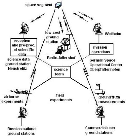
Mission Architecture and Ground Segment
Mission operations by DLR Data reception, processing storage by DLR Coordination of the user requirements by an operational user interface Commercial distribution of fire data products Technology
demonstration of
hyper-spectrometer Option:
direct receiving of data by low-cost ground stations including processing software


BIRD-Highlight:
Hot-Spot-Detection Within the Sub-Pixel Range
(Dozier,
1981: Bi-spectral
Technique for retrieving temperature and area of sub-pixel hot spots)


LMIR (TF, q) = q BMIR (TF) + (1-q) LMIR-bg
LTIR (TF, q)
= q BTIR (TF)
+ (1-q) LTIR-bg
BMIR/TIR
- integral
Planck-Function within each channel LMIR/TIR-bg
– estimated radiance of background from the surroundings
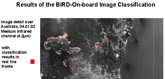
Infrared+hyperspectral remote sensing technologies: demonstration of usage
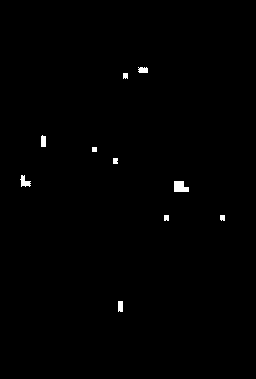
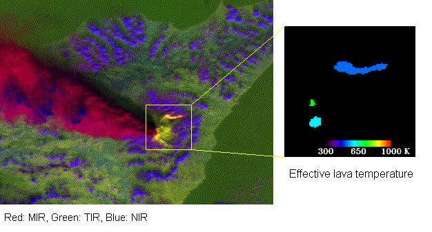
First Fire Evaluation From Space -
BIRD gives temperature and area extent
of Australian bush fires
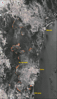
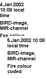
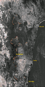
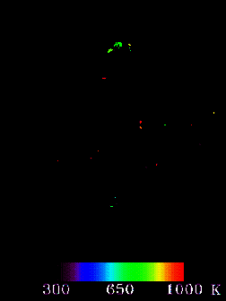
Comparison
of the fire images and fire data products between MODIS and BIRD (detail image
from 5. Jan. 2001
of Australia)
MODIS: Fire map BIRD: Fire map
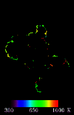
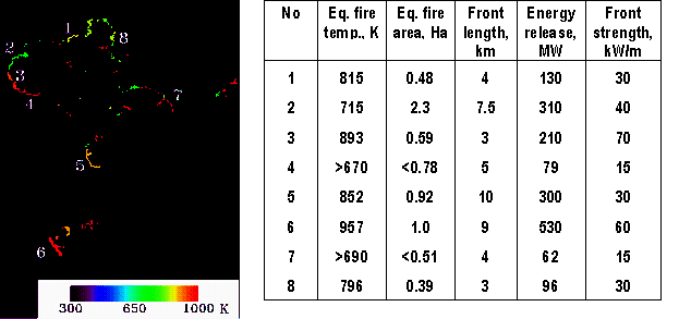
Typical characteristics of fire fronts
(BIRD, Australia, January 5, 2002)
Etna
eruption (BIRD, November 2, 2002)

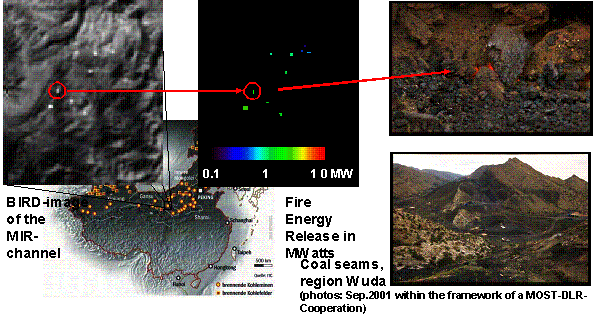
BIRD
Detects Coal Seam Fires in China (February 6, 2002)
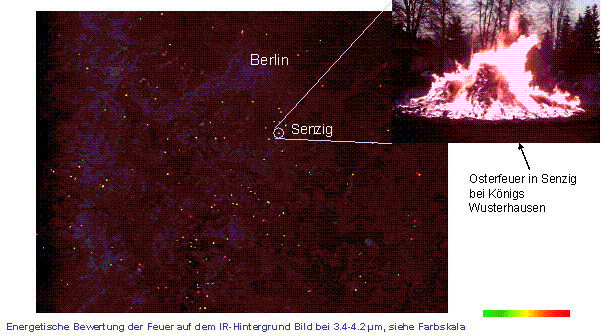
Osterfeuer (BIRD - Aufnahme, Region Berlin-Süd, 17. April 2003, 22:35 MEZ)
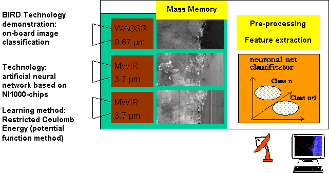
Classification of images in VNIR and MWIR

To increase
the robustness and accuracy of on-board image classification, hyperspectral
data should be used, in addition to IR data. This could provide the additional
detailed information on the chemical composition of combustion products and on
the environmental impact of fires.
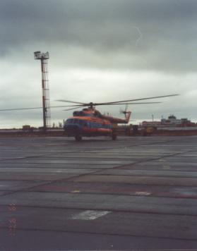
R&G Center “Reagent’ has designed, developed, and tested the Astrogon
airborne prototype on board the helicopter.
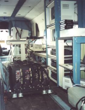
Images
from two hyperspectral modules at different wavelengths as seen on board the
helicopter.
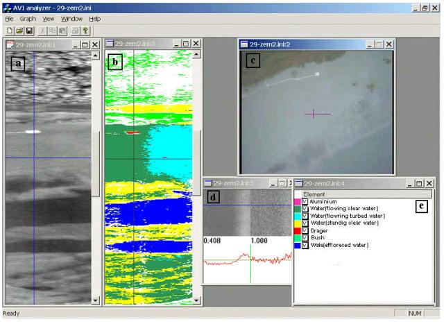
|
Examples of hyperspectral
information and processing results |
|
|
a |
B/w representation of total
hyperspectral signal. |
|
b - |
Classification resulting from
correlational processing of hyperspectral data. |
|
c – |
Accompanying camera view (total camera
viewing angle 600, hyperspectrometer viewing angle 120
shown as a horizontal line). |
|
d – |
Upper half: data from two
hyperspectrometer modules corresponding to the cross-point in a, b, and с. Lower
half: spectrum in the cross-point. |
|
e – |
List of categories used in classification. |
Benefits of
Cooperation
The hyperspectrometer
“Astrogon-Light” on an operational Fire Monitoring Constellation would give:
·
New scientific results related to land, sea surface
and atmosphere
·
Demonstration of advanced technology in space
·
New knowledge about environment and security
·
Additional scientific results about fire and volcano
impacts
·
Different application products on user request
·
Additional detailed information on the chemical
composition of combustion products and terrestrial objects.
Conclusion
The joint Russian-German Project
proposed is based on the combined use of an infrared camera and a
hyperspectrometer carried by the BIRD-type satellite cluster. It opens a new
vista in global and regional monitoring of critical processes and catastrophes,
such as forest fires, volcano eruptions, technogenous disasters, etc. The new
capabilities are due to the synergistic effect of infrared and
hyperspectrometric data. The following features add to the perspective of the
Project:
1. Temperature
and area extent of vegetation fires or other hot spots can be evaluated from
space.
2. The new
infrared array sensor system is suitable for small satellite missions.
3. New
hyperspectrometer data offer new science and new service for monitoring of
environment and security.
4. Micro–satellites
are interesting tools for operational missions open because of the low mission
costs and the flexibility.
5. An
operational Fire Monitoring Constellation is “First to market”
6. An
operational hyperspectrometer is “first to science” and “first to market”.
APPENDIX
|
|
APPROVED Vice-President
of Russian Academy of Sciences, President
of the Section “Space investigations of the Earth and natural resources”, RAS
Scientific Council on Space Investigations, Academician N. P.
Laverov “15”
December 2003 |
Experimental
study of regional and global terrestrial environmental processes using
spaceborne hyperspectral and infrared sensors
Scientific
program
Moscow, 2003
Introduction
Fires and
other natural and anthropogenic catastrophes, such as trunk pipeline failures,
large power plant accidents, volcano eruptions etc. lead to emission of
enormous quantities of heat and cause several hundred million dollar losses
yearly to environment, industry, housing, and population health.
The timely
detection of events that start these catastrophes would help their prevention
or, at least, would help in reducing their extent. The first thing to do is to
provide the local administration and the specialized services with an adequate
informational support, in order to track the catastrophe development from
precursors to outbreak, the peak of event and then to post-catastrophic
processes. A widely varying spatial coverage is usually required for that.
The solution
to this problem can be based only on spaceborne remote sensing, armed with
sensitive infrared sensors and with visible and near-infrared
hyperspectrometers with high simultaneous spatial and spectral resolution.
Hyperspectrometers are a must for screening out artifacts, detecting weak
precursor symptoms, assessing the slow post-catastrophic dynamics. However,
sensors are not the only hardware necessary: receiving stations, preliminary
processing complexes, storage and distribution network – all that must be taken
into account. The software – thematic processing algorithms and decision
support systems adapted to fast response requirements characteristic for
catastrophes - is as important as hardware. Both hardware and software should
function on a permanent basis, in order to support precursor monitoring and
post-catastrophic management.
As a
prototype of the space-based part of such a system, one could indicate the BIRD
satellite (Germany) with an infrared sensor. It has been functioning from 1999
till 2003. Its information proved quite effective in forest fire and volcano
monitoring. However, for this system to live up to challenges listed above, it
should be complemented with a hyperspectrometer. In our opinion, an adequate
sensor for this purpose is the Astrogon-Light hyperspectrometer developed by
R&G“ Reagent” (Russia).
This paper
contains a proposal for development of a joint Russian and German small
satellite-based Earth monitoring system targeted at natural and technogenic
catastrophes with high energetic yield – fires, etc. It should be based on
fusion of German infrared data and Russian hyperspectrometric data.
This
proposal is supported by Russian Academy of Sciences. It covers the project of
the system, experimental results from German infrared sensor, and results of
test flights with Russian hyperspectrometer. The appendix includes the
scientific program “Space-based experimental study of global and regional
environmental processes using hyperspectral and infrared sensors” by Russian
Academy of Sciences.
General
Justification
Recent
decades have seen a number of programs and experiments in spaceborne remote
sensing domain, both in Russia and abroad (LACIE, Seasat, FIFE, BOREAS etc.).
Nevertheless, no implementation of regional or global environmental study,
either targeted to atmosphere or to oceans or land, can be considered adequate.
The basic reason is the so-called inductive approach, so that the objects of
study were confined to individual biospheric components or processes, and the
global picture was supposed to emerge from later synthesis of results. This
approach inherently suffers from possible omissions or duplications or wrong
weighting of the objects, and, consequently, leads to dissipation of resources
and loss of time.
There
is an alternative: the deductive approach based on the search for optimization
of a chosen criterion, e.g., sustainability of global environmental and
socio-economical development, closure of natural cycles of matter and energy,
quality of human life, etc. The list of necessary studies and methodologies
would follow as an ‘unfolding’ of the criterion functional. This approach is
widely used, e.g., in controller synthesis, statistical decision theory and
many other scientific and technological domains.
This
approach, if adopted, would call for a new informational support strategy for
research, and, in particular, the strategy of space-based remote sensing.
Specifically, the set of so-called unfolding parameters, such as wavelength,
spatial coordinate, observation angle, scale, etc., should be made as rich as
possible. Also, all components and stages of remote monitoring, which use these
parameters, should be integrated into a coherent system – beginning with
problem statement and ending with marketing issues.
The
space-based experiment we propose is a first step towards implementation of
this strategy, testing its basic principles and providing a starting point for
methodology of further studies. The experiment is based on spaceborne
hyperspectral (0.3 – 2.5 µ) and infrared (4 – 12 µ) instruments, and its
methodology would be extensible to other wavelengths.
The approach
proposed implies the implementation of fundamental science through applied
research, so that there is a feedback between scientific and practical
problems. In particular, the scientific program is dependent on the #1
marketing issue: the traditional data, such as panchromatic and multispectral
images, are a standard product on the market. They have almost a status of
utility, their turnover is skyrocketing and could reach $20 billion by the year
2010.
The
situation is different for a more complex type of data – the hyperspectral.
Their strong point is the possibility of remote physical and chemical analysis
of Earth surface. However, the data processing methodology is still to be
developed and tested, and until then, the commercialization is delayed. An
important part of the program proposed is to remove the scientific obstacles
and open the way first towards the engineering applications, and then towards
commercialization of hyperspectral data.
The infrared
camera, which is a part of onboard instrumentation, will be provided by a
consortium of German enterprises:
·
OHB System AG, responsible for satellite bus and launch
·
Jena-Optronik GmbH, responsible for the Payload Segment
·
DLR, responsible for mission operation and IR-technology
·
Technical University of Berlin,
Mission Planning and project management
·
Fraunhofer FIRST, payload interface
unit and payload data processing.
At the Russian – German
meeting on September 17, 2003, Rosaviakosmos has presented its proposals on the
integration of information flows from Russian and German satellites.
Purpose of the
program.
This document presents a
joint scientific program by a number of leading RAS institutes (Keldysh
Institute of Applied Mathematics, Semenov Institute of Chemical Physics, Center
of Forest Ecology and Productivity, Institute of Atmospheric Physics, Institute
of Oceanology, Institute of Geology of Ore Deposits, Petrography, Mineralogy,
and Geochemistry, Lebedev Physical Institute), Center of Science-Intensive Export Technologies, and
R&G “Reagent”. It includes the following sections:
-
goals,
objectives, and contents of the experiment;
-
basic
requirements for the experiment and for the methodologies of data processing;
-
organizational
requirements for the implementation of the experiment;
-
other
organizational issues.
Goals
and objectives of the experiment
Main goal
Using the
spaceborne hyperspectral and infrared remote sensing for discovery and study of
interaction mechanisms between various biosphere components (atmosphere, ocean,
and land) and between them and anthropogenic systems, in order to develop the
strategy of monitoring and controlling these systems’ state as an informational
support for global sustainable development, economic activities, early natural
and anthropogenic catastrophe warning, and assessment of their after-effects.
Scientific
and practical objectives
This goal implies:
·
Definition,
based on the above-mentioned deductive approach, of most urgent and/or most
perspective scientific and applied problems, in a setting optimized by
informativity of hyperspectral and infrared observations with respect to
objects and processes involved;
·
Determination
of data informativity within each problem group as a function of time,
territory, observation schedule, data processing methods. Optimizing the
monitoring strategy for each problem group with respect to these parameters;
·
Definition
of requirements to auxiliary databanks: GIS information, additional databases,
knowledge bases, and, most importantly, in situ experimental data. Developing a
preliminary version of integrated auxiliary databank.
·
Development
of requirements for information channels and information shipment conditions,
based on the dependence between admissible shipment delay, information volume,
and processing depth and quality;
·
Assessment
of market capacity as a function of problem group and the quality of
information. Assessment of total development and exploitation cost and expected
profitability of the information system based on hyperspectral and infrared
remote sensing.
·
Developing
the list of standing customers and coordinating the requirements for
information products with them. Securing the informational support with
problem-related in situ information from customers.
·
Forming
an expert group for scientific and methodological supervision of the
information system;
·
Feasibility
study for a new way of information shipment based on peer-to-peer Internet
networks including both individuals and institutions. This is especially
valuable for catastrophe monitoring and control, e.g. targeted to population
health during intensive forest fires;
·
Feasibility
study for a continuous monitoring-control feedback cycle for customers who wish
to participate in this study.
Scientific and applied
problems and application domains for the results of experiment
The
following list of scientific and applied problems and expected results is
preliminary. It will be refined as the work listed in section 0 will progress.
Table 1 Application
domains and expected results
|
## |
Problem |
Expected results |
|
1. |
Diagnostic
of main gas and oil pipelines |
Pipeline
positioning, monitoring of intersections, detection of protection zone
infringements, forecast of slumps and arches, detection of micro-fractures
and fistulas, detection of corrosion, soil and ice-lens dynamics, illegal
cut-ins. |
|
2. |
Monitoring
of deposit infrastructure |
Monitoring
the state of collector networks, roads, production sites |
|
3. |
Monitoring
of underground gas reservoirs |
Leak
zones, leak volumes |
|
4. |
Monitoring
of oil reservoirs |
Reservoir
fillup, shell deformation, product leakage (including subsurface leakage) |
|
5. |
Environmental
support of land-based and offshore drilling |
Condition
of settling pits and reservoirs, leakages of drilling fluid, of mineralized
stratal water, oil or condensate. Detection of oil spills on sea surface. |
|
6. |
Environmental condition of deposits |
Anthropogenic
defects of landscape, soil, vegetation, subsurface flow |
|
7. |
Environmental
condition of trunk pipelines |
Biota
suppression zones caused by micro-leakages |
|
8. |
Potential
borehole positioning. Monitoring of deposit exhaustion |
Periodically
renewed 2-D and 3-D deposit maps. Monitoring of strategic oil and gas
reserves |
|
9. |
Monitoring
of construction and repair activity on tracks |
Monitoring
of work progress and of excavation and filling volumes |
|
10 |
Selection
of new trunk pipeline tracks |
Size and
value of lands put out of use, soil composition, shorelines, slope stability,
river crossing stability |
|
11 |
Exploration
geology |
Delimitation
of complex ore-bearing formations, ore typology and chemistry, small deposit
halo |
|
12 |
Construction
geology |
Tectonic
faults, karst, running sand |
|
13 |
Engineering
geology |
Mine
surveys, design of pipelines, dams, channels, and nuclear power stations |
|
14 |
Highway and railway diagnostics |
Permafrost,
subsidence, and landslide-caused deformations, disturbances of road-bed and
pavement, condition of railroad track and trolley-wires |
|
15 |
Monitoring
of bridges and beam crossings |
Segments
in stressed and deformed state |
|
16 |
Airfield
monitoring |
Condition
of landing strips and runways |
|
17 |
Monitoring
of power transmission lines |
Track
certification (digitizing the power transmission poles), damage to insulators
and poles, disruption of passages |
|
18 |
City
infrastructure, surface and subsurface networks, power lines, heating
systems, water supply and sanitation, gas supply, transport |
GIS
information: topology of networks and damages, air and soil pollution zones
by industry and transport. Approaches by emergency services to potentially
dangerous sites and extraordinary events. Zones of town-planning value,
cultural heritage. |
|
19 |
Exact
cartography |
Visual
maps (CD-ROM) of cities, cross-country, surveying party or tourist routes |
|
20 |
Cadastral
mapping and capacity mapping in megalopolises, high farming regions, health
resort zones, and natural reserves. Environmental condition of freshwater
sources. |
Updatable
database of property rights and differential rent. Detection of continuous
and extraordinary pollutant emissions and localization of sources |
|
21 |
Marine
fishery monitoring |
Zones of
upwelling and turbulence, currents, spatial distribution, concentration, and
gradients of chlorophyll, phytoplankton, organic and inorganic suspended
sediments, salinity, and temperature |
|
22 |
Borderguard
services |
Position
of commercial fishery ships in zones of economical interest |
|
23 |
Agriculture
and forestry, including farming and nurseries |
Spatial
heterogeneity of fertilizers and additives’ composition and dosage, sprout
condition, vegetation stages, phytomass, diseases and pests, yield forecast,
damage assessment for insurance purposes |
|
24 |
Forest
fire monitoring |
Detailed
damage localization within fire site, target designation to fire services |
|
25 |
Monitoring
of deep and near-Earth space |
Earth Limb
imaging, detection of space debris and other objects, measurement of ozone
layer state. Tomography of upper atmosphere. |
|
26 |
Monitoring
of catastrophe precursors for floods, ice jams, high dams, quarries, sludge
ponds, tailing pits, chemical plants, nuclear power stations. |
Anomaly
identification, forecast of dynamics |
|
27. |
Volcano monitoring |
Dynamics
of gas, ash, and magma emission. Zones of potential danger to population |
Scientific
and methodological basis
Relationship between
system-defining factors
Scientific
and methodological basis for this program is provided by the methodology for
development of information-optimal remote monitoring systems. The methodology
was developed in Space Research Institute, Russian Academy of Sciences. Nine
major groups of system factors are taken into account and related to each
other:
-
Monitoring problem statement (major objects,
parameters and processes);
-
Imaging platform and schedule;
-
Parameters of sensors (here, of the hyperspectrometer
and IR-camera);
-
Prior and in-situ information;
-
Algorithms of preliminary data processing and
correction;
-
Algorithms of thematic data processing, including
specific analytical and empirical models used;
-
Logistics of information shipment from sensors to
processing center and from processing center to users;
-
Marketing factors and business process definition
focused on overall profitability of the system;
-
Procedures used to adapt the system to changes in
problem setting, technology, market situation etc.
There are two basic types of relationship between these factors. The
first one includes fixed constraints, which limit options within a factor group
(e.g., monitoring schedule) as a function of choice made within another factor
group (e.g., problem statement choice). The second one includes ‘soft
relationships’ defined by coefficients of information transfer from a factor to
another factor (e.g., from a model of object dynamics to probability of success
in the object detection problem). When all relationships are taken into
account, the methodology provides an algorithm for identifying the viable,
mutually compatible and informationally optimal configurations of factors. Each
distinct cluster of factor configurations defines a distinct feasible type of
the monitoring system. The choice between these options is the crucial system
design decision. To a large extent, it is determined by the choice and weights
of application domains.
The target
monitoring problems are detailed into factors:
o Application
domain definition (e.g., for the federal forest fire aviation service, this
includes fire detection, fire monitoring, and fire extinguishing);
o Definition
of objects that have to be detected;
o Definition
of spatially extended systems that have to be mapped;
o Definition
of quantitative parameters that have to be estimated;
o Definition
of dynamic processes to be taken into account within some dynamic modeling
framework;
o Indicator
characteristics of objects, processes, etc., that allow for remote monitoring.
Capacity and
informativity of data channels
Remotely
sensed data obtained for training areas with in-situ measurements and other
background information are used to calculate the capacity of information
channels that connect sensors to users. Other factors are taken into account,
as well, as intermediate nodes of information flow: indicator characteristics
specific to application domain, methods of preliminary and thematic processing,
methods of information shipment etc. Then, marketing studies are used to
calculate the expected feedback from quality of information shipped to users to
demand for information in different application domains, and then, to expected
sales. Iterations of this modeling cycle will converge to the financial
equivalent of a unit of information. Then, the cost-effectiveness criterion can
be used to optimize the system design. Note that informativity parameter
includes only the information that goes intact through this cycle and, in
particular, is assigned a financial equivalent.
From
experimental to operational mode
The tests
that follow this methodology solve two related problems. First, they provide
basic data, and in particular, remote sensing data, necessary for model
calculations described above. Second, the results of modeling are used to
correct the imaging schedules, data processing methods, data shipment
procedures, etc. Thus, testing is more than a study: it is a practical
informational design optimization of the environmental monitoring system based
on hyperspectral and thermal imaging. As a result, the transition from
experimental to operational mode will, hopefully, become smoother. In
operational mode, the same methodology still remains valid as a way of adapting
the monitoring system to changes of market and of other factors.
Improving the technology
of hyperspectral and infrared remote sensing
This line of activity includes:
o obtaining
the paired sets of remote and in situ synchronous or quasi-synchronous,
spatially compatible data, setting up the corresponding archives, databases and
knowledge bases;
o development
of data validation methodology for remote and in situ studies;
o development
of planning and survey methodologies for remote and in situ studies at test
sites;
o determining
the invariant relations between observed spectral reflectance / brightness
temperature and parameters characterizing the state of remotely sensed objects;
o determining
the relations between observed spectral reflectance / brightness temperature
and parameters characterizing the composition of atmosphere above the remotely
sensed objects;
o development
of methodology for remote identification of atmospheric pollution sources from
estimated pollutant concentrations;
o identifying
the existing and developing the new dynamical models to be used in monitoring
and control of specific objects;
o improvement
of thematic data processing algorithms for remote and in situ measurements;
o development
of external calibration technology for onboard imagers.
Requirements
for test site selection
Test sites
play a major role in implementation of this space-based experiment, especially
within the new deductive framework.
First, they provide the crucial background information; second, they are
necessary for validation of thematic processing results.
Therefore,
test sites should be selected so that they a) contain a maximum possible
diversity of natural and anthropogenic objects; b) be well studied during many
years’ field experiments; c) be related to economically important application
domains; d) be well covered with past remote sensing data, with topographic and
thematic maps.
Basic
requirements for the experiment
Preliminary stage
This stage
includes:
o preparation
of ranked lists of application domains and specific problems within each
domain, linked to potential customers and virtual test sites;
o solving the
organizational issues of test site equipment for future experiment, onboard
instrument calibration, data processing validation;
o collection,
systematization, analysis, and, if necessary, extension of existing background
information for selected test sites, in order to support the synchronous
spaceborne and in situ experiments and the processing of respective data;
o solving the
organizational and methodological issues of information buildup and shipment to
users;
o development
of advanced thematic data processing algorithms.
Experimental stage
The experimental stage is expected to produce the
following results:
o
the full set of planned remote and in situ
measurements performed;
o
informativity of measurements with respect to the
preliminary set of application domains should be estimated;
o
organizational and marketing measures defined, in
order to promote the usage of data in global and regional environmental studies
and in geographical information technologies used in various industries;
o
potential improvements of remote sensing instruments,
increasing their scientific and commercial usability, should be defined.
Organizational
issues
The
experiment spans the period 2004 – 2015.
The leading
executive offices are:
o Keldysh
Institute of Applied Mathematics, Russian Academy of Sciences, – in trajectory
calculations, imaging schedule, preliminary atmospheric correction;
o Semenov
Institute of Chemical Physics, Russian Academy of Sciences, - in studies of
chemical composition of remotely sensed objects, methodology and organization
of thematical interpretation of remote and in situ data;
o Lebedev
Physical Institute, Russian Academy of Sciences, - in studies of tropospheric
gases distribution by means of correlational infrared radiometry from
spaceborne and mobile terrestrial platforms. Participation in validation of
hyperspectral measurements using a multispectral infrared spectroradiometer;
o R&D
Center “Reagent” – in providing the onboard hyperspectral and infrared sensors,
organization of test site studies, thematical processing of data. Includes the
validation of hyperspectral data in helicopter/aircraft flights to obtain test
data for analysis;
o Semenov
Institute of Chemical Physics Centre of Export High-Tech – in marketing and
commercialization of results.
Other participants: Center of Forest
Ecology and Productivity, Russian Academy of Sciences; Institute of Atmospheric
Physics, Russian Academy of Sciences; Institute of Geology of Ore Deposits,
Petrography, Mineralogy, and Geochemistry, Russian Academy of Sciences;
Institute of Oceanology, Russian Academy of Sciences.
References
А.А.Belov, D.V.Vorontsov,
D.Yu.Dubrovitskii, А.P.Kalinin, V.N.Lubimov, L.A.Makridenko, M.Yu.Ovchinnikov,
А.G.Orlov, A.F.Osipov, G.M.Polishuk, A.A.Ponomarev, I.D.Rodionov, А.I.Rodionov,
N.A.Senik, N.N.Chrenov, “Astrogon-Vulkan” small spacecraft for high resolution
hyperspectrometer, Preprint of IPMech RAS, № 726, 32p., 2003 (in Russian).
A.A.Belov, P.Behr, E.Yu.Fedounin,
A.A.Ilyin, S.K.Kalashnikov, A.P.Kalinin, S.Montenegro, A.G.Orlov, A.N.Ostanniy,
A.M.Ovchinnikov, M.Yu.Ovchinnikov, S.Pletner, I.V.Ritus, A.I.Rodionov,
I.D.Rodionov, I.P.Rodionova, D.V.Vorontsov, B.V.Zubkov, Software for the
Distributed On-board Computer System Prototype, Preprint of KIAM RAS, N 14,
22p., 2004.
А.А.Belov, D.V.Vorontsov,
B.V.Zubkov, А.P.Kalinin, A.A.Ilyin, .А.M.Ovchinnikov, А.G.Orlov, I.D.Rodionov,
А.I.Rodionov, I.B.Shilov, E.Yu.Fedounin, А.N.Ostanniy, S.Pletner, P.Behr,
S.Montenegro, Distributed On-board Computer System Prototype, Preprint of IKI
RAS, № Пр-2097, 25p., 2003 (in
Russian).